The Scenic Splendor Series – Seas
Update:
Kihoku Town
Owase City
Kumano City
Mihama Town
Kiho Town
The Higashikishu coastline boasts two distinct features—a ria coast with intricate coves and a gently curving beach.
Spanning a linear distance of 70km between Kihoku-cho and Kiho-cho, visitors can marvel at the magnificence and mystery of nature with the stunning view of white clouds in the blue sky interwoven with the sea.
For those seeking scenic sea spots, we recommend the Mt. Takatsuka Observation Platform, offering panoramic views of the sea and mountains; Temmado viewed from the prefectural road; Ohai and Tategasaki accessible by sightseeing boat; and Shichirimihama with its relaxing waves and melodic atmosphere.
▼目次
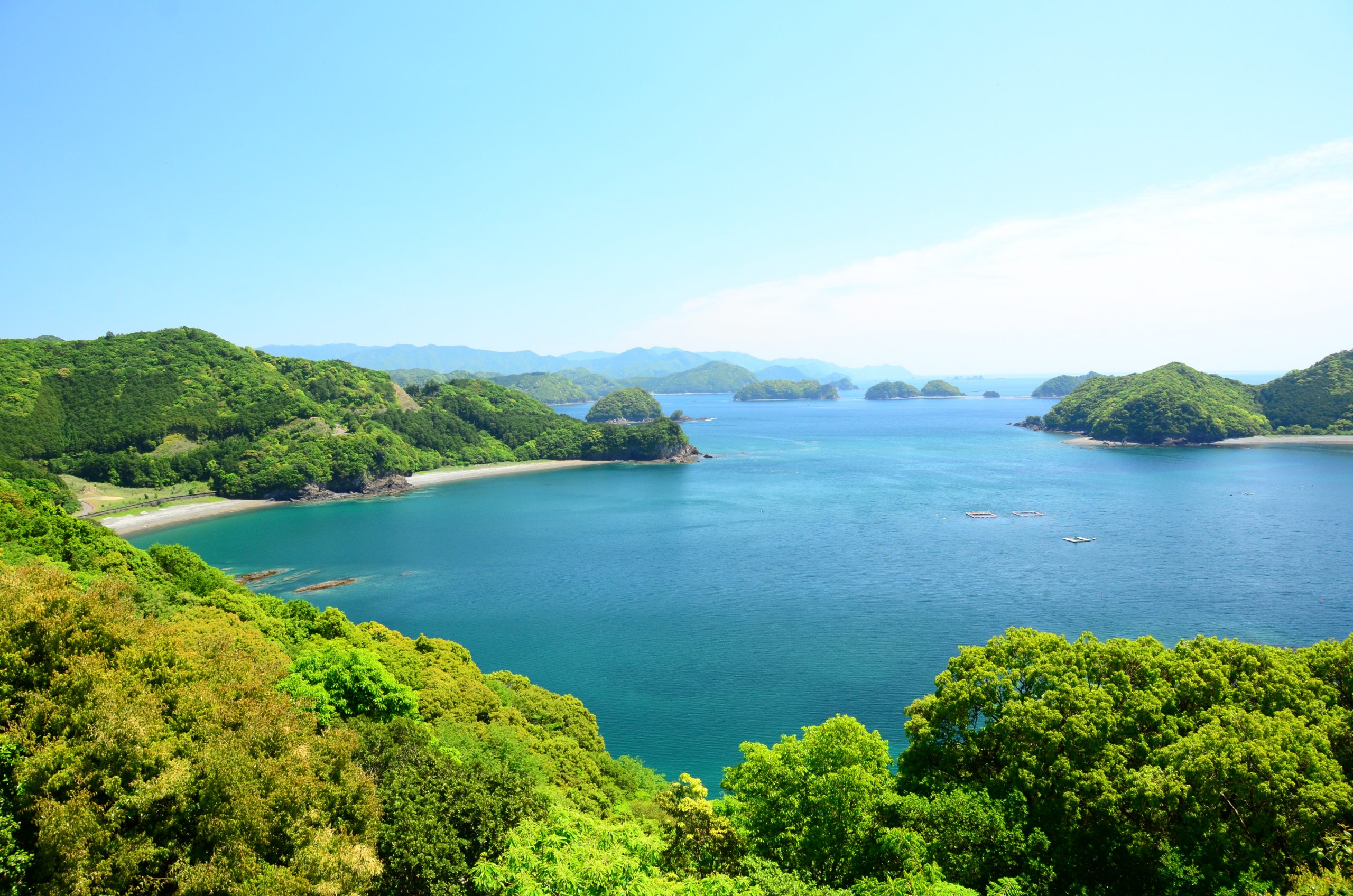
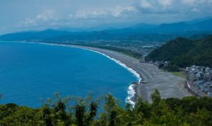
1 The Mt. Takatsuka Observation Platform 74m [Kihoku-cho] Kumano Nada Seaside Park
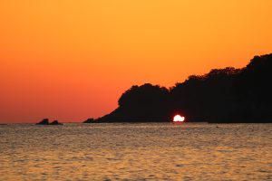
2 Temmado [Kihoku-cho] Prefectural Designated Cultural Property Scenic Spot for Sunrise
3 Ohai [Owase City] Ohai Blue
4 Tategasaki [Kumano City] Umikongo Rock Gama no kuchi
5 Shichirimihama [Kumano City, Mihama-cho, Kiho-cho] World Heritage Site
The 100 Beaches of Japan 100 Natural Wonders of Japan in the 21st Century
1 The Mt. Takatsuka Observation Platform 74m [Kihoku-cho] Kumano Nada Seaside Park
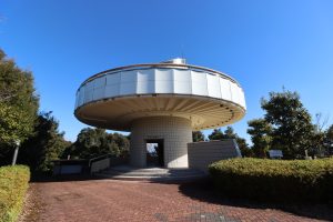
Situated at an altitude of 74 meters, Mt. Takatsuka is a picturesque destination that provides an excellent view of the Kumano-nada.
Located in the midst of the abundant natural surroundings of Kihoku-cho, Kumano Nada Seaside Park has an observation platform that is placed atop Mt. Takatsuka.
It takes around five minutes to climb up the slope, which is enveloped by verdant greenery.
The white observation platform is visible at the end of the climb, and the circular building is considered a photogenic spot.
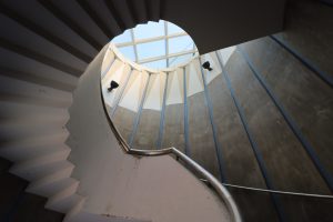
Climb up the spiral staircase and upon reaching the second floor, visitors can take a 360° stroll around the structure to relish the vast and stunning view of the Kumano-nada.
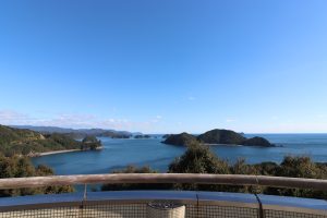
Marvel at the breathtaking sight of the numerous islets of Kii-no-Matsushima against the boundless expanse of the blue sky and sea.
On days with good weather conditions during autumn to winter, visitors can also enjoy the panoramic view of the Shima Peninsula.
Use the free telescope for a closer look at the sights.
The scenery at Mt. Takatsuka is a constantly changing and breathtaking spectacle.
During the day, you can marvel at the view of the blue sky, sparkling sea, and picturesque islands, while at night, you can observe the Milky Way stretching across the starry sky until the crimson sun rises from between the islands.
Each season brings its unique charm to the landscape, making all of them exceptionally beautiful.
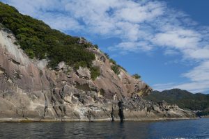
2 Temmado [Kihoku-cho] Prefectural Designated Cultural Property Scenic Spot for Sunrise
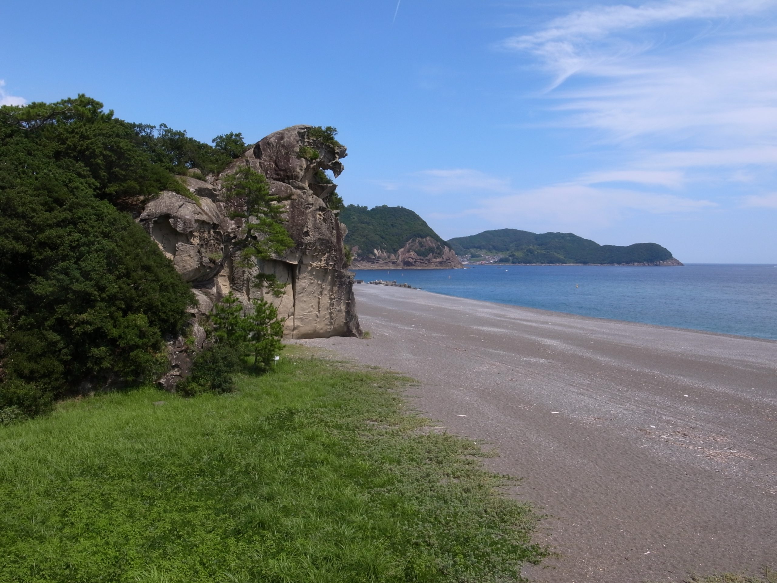
As you travel through the village along Yaguchi Bay in Kihoku-cho and exit from the Shimakatsuura Tunnel, you’ll catch a glimpse of Funakoshi Beach on your left.
If you observe the cape jutting into the sea closely, you’ll notice a prominent hole from a specific angle.
This is Temmado, a natural cave formed by the erosion of turbulent waves that created a tunnel-like structure.
The rocks, such as sandstone and slate, are thought to have formed in layers, and the weaker portions were gradually eroded away, creating the hole.
Although other sea caves are visible along the surrounding coast, Temmado is known for its size, with a diameter of approximately 20 meters and a depth of about 30 meters, making it one of the largest in the prefecture.
It was designated as a prefectural natural monument in February of Showa 53 (1978) under the name “Shimakatsu Sea Cave.”
Floating off the coast of Funakoshi is Oshima, a nationally designated natural monument.
It is a haven for a variety of precious warm-climate plants that are grown and preserved in near-primitive conditions.
This island is also known for its appearance as Iwayajima in “Large Gold Bullion,” a Shounen Detective series by Ranpo Edogawa.
Temmado cannot be reached by road, but there is an observation spot near Nakaguma Elementary Park across the prefectural road.
Additionally, some people choose to observe the first sunrise of the new year at Funakoshi Beach.
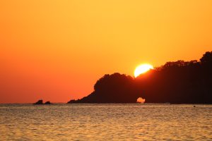
Temmado is especially popular during the days before and after the vernal and autumnal equinoxes.
During this time, photographers flock to the cave in hopes of capturing the ethereal shot of the sun rising from the mouth of the cave.
The breathtaking coastal landscape, formed by the forces of nature over time, continues to capture the hearts of all who see it.
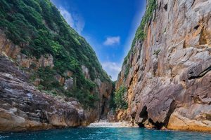
3 Ohai [Owase City] Ohai Blue
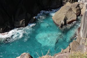
Located in Kuki-cho of Owase City, Ohai is a hidden treasure with breathtaking views known as “Ohai blue”.
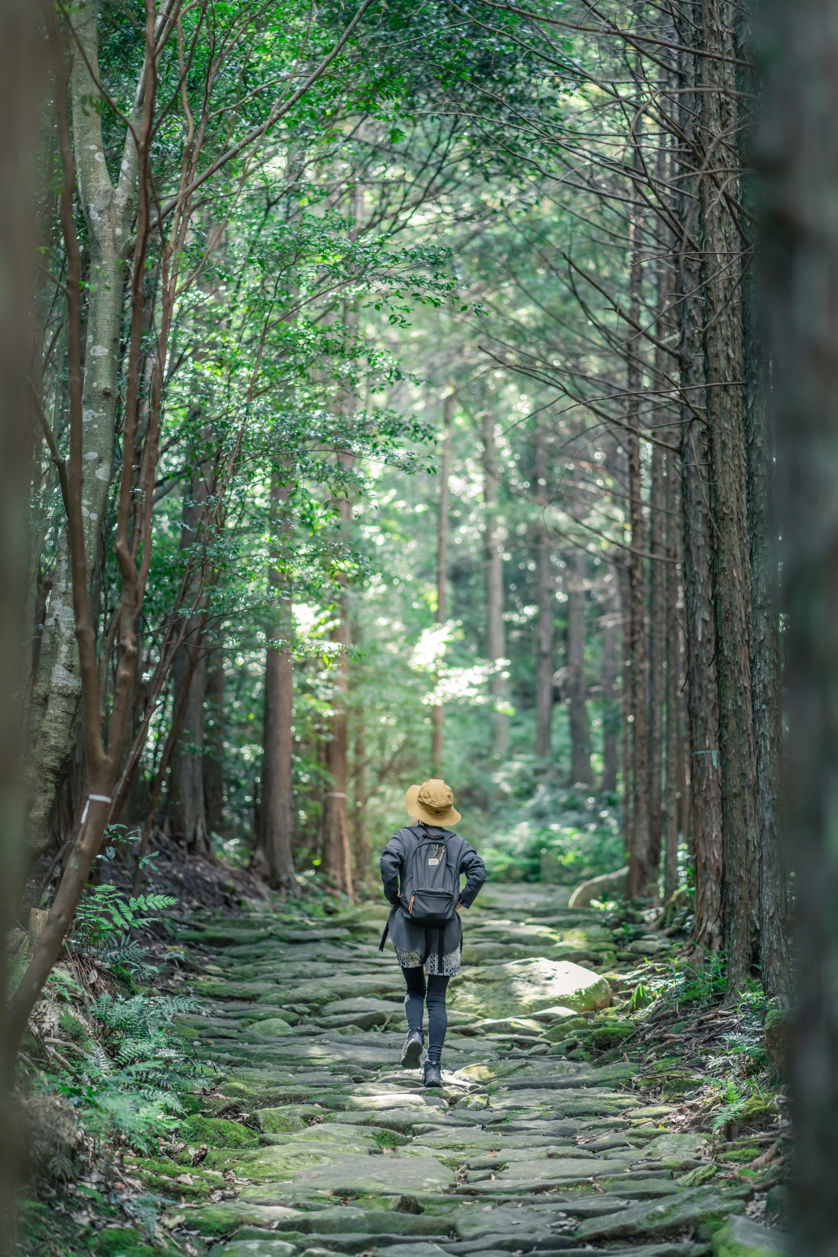
To get there, visitors must hike a mountain trail that takes approximately an hour and a half.
Ohai is nestled in Kukisaki, facing Kumano-nada, and from the massive rocks surrounding the area, you can enjoy stunning views of Kumano-nada.
When the light shines behind the sheer cliff, the water’s surface glows with a deep blue hue, known as “Ohai blue.”
However, this natural wonder can only be observed from land for a few hours daily.
Alternatively, visitors can opt to take the Ohai cruising service, offered by Enba Seijira, which operates guesthouses and fishing boats in Kuki-cho.
To start the Ohai cruising experience, head to the Kuki Bay quay where the boat awaits.
Life jackets are provided before embarking on the cruise.
As you sail around the bay, take in the sight of the densely packed houses while feeling the refreshing sea breeze.
The cruise will pass by Nasazaki and Manaita Shimabana before reaching the fishing grounds set up by Kuki Teichigyogyou (set-net fishery), and finally arriving at Ohai.
Ohai is a local term for “big cliff” and can be written in kanji as ‘大配 (ohai)’, with the word ‘配 (hai)’ meaning a cliff or an abyss.
Admire its towering presence up close from the boat.
After leaving Ohai, the cruise will stop by other picturesque spots such as Ababa (Café & Coworking) and Hebi no kuchi, where a cave-like structure is formed between rocks, making the entire trip last between an hour and a half to two hours.
Enba Seijira ☎080-2080-3080 Suzuki
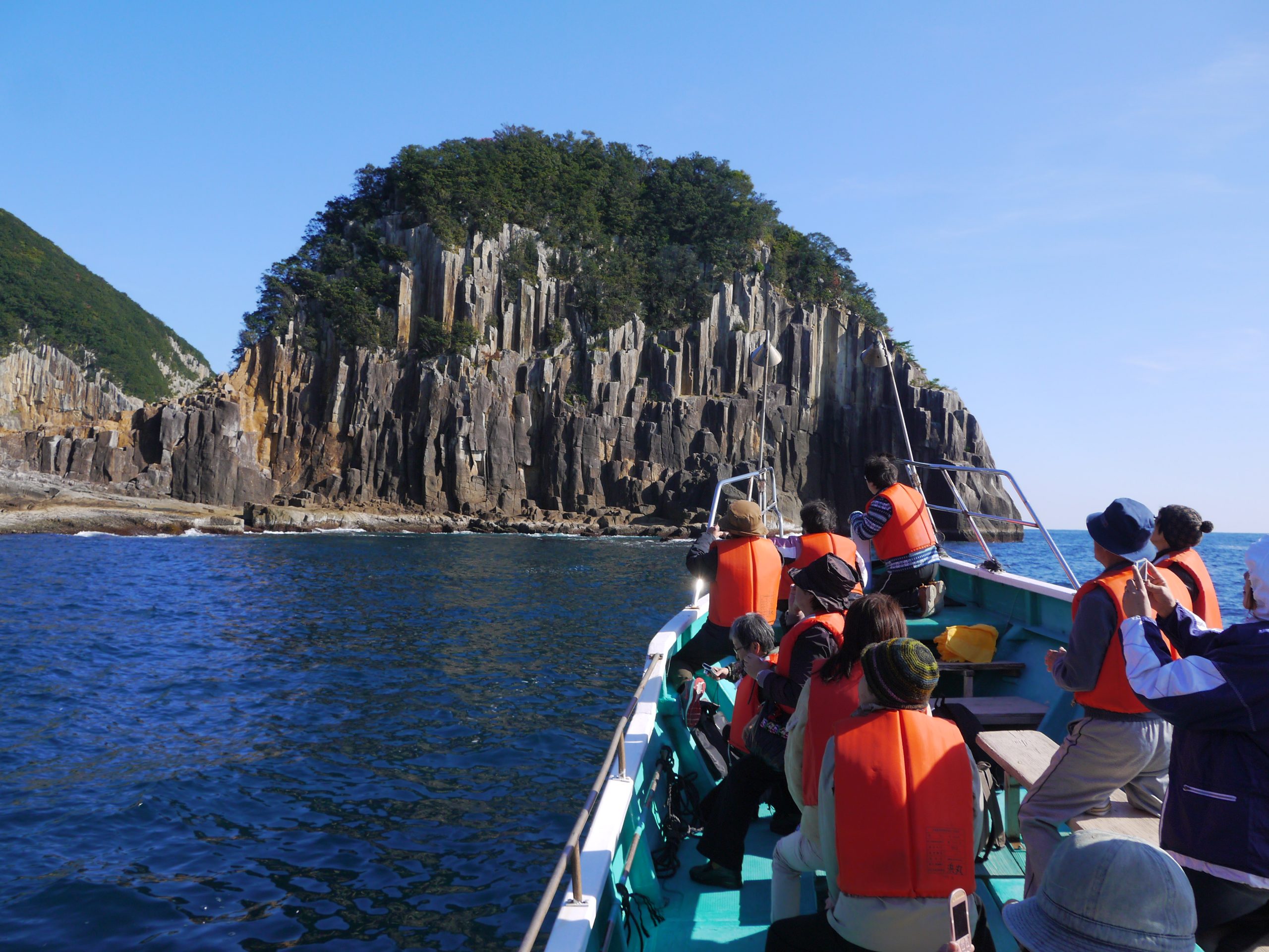
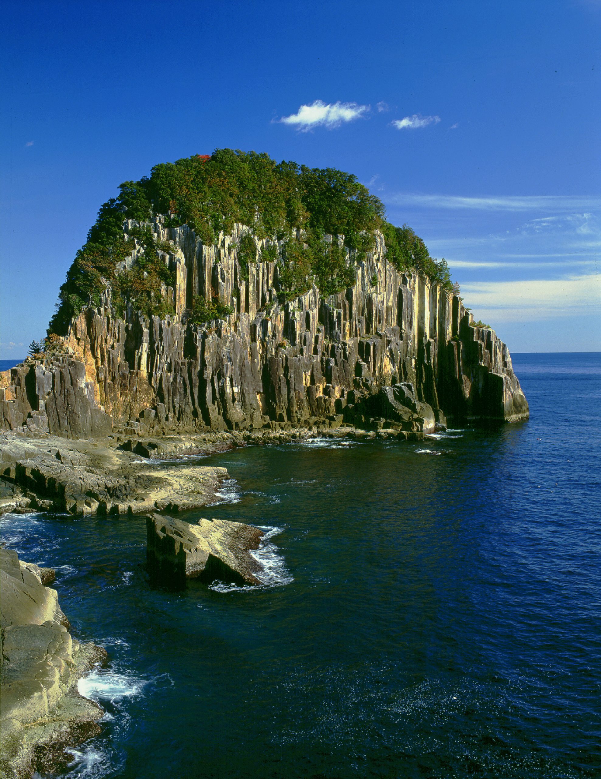
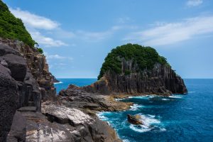
4 Tategasaki [Kumano City] Umikongo Rock Gama no kuchi
The Tategasaki Sightseeing Boat departs from Matsuzaki Port near Onigajo (Demon’s Castle) and offers a 70-minute cruise that showcases unique sceneries of Kumano.
The beautiful Kumano-nada, columnar joints, and numerous huge and strangely-shaped rocks can be admired during the journey.
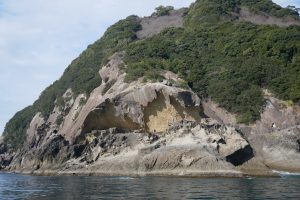
As you set out, your first stop will be Onigajo, which extends along a cape. From the sea, you’ll observe the uniqueness of its topography.
The sea cave, formed through repeated upheaval, weathering, and erosion from strong waves, is a true masterpiece of nature.
Moreover, this is the only location where you can view both the gentle arc of Shichirimihama and the intricately winding ria coast simultaneously.
Make a sharp turn and head towards the northeast direction.
The fishing industry in Isozaki, Yuuki and the neighboring coastal villages is flourishing.
You’ll be amazed at the multitude of people who take the ferry to fish on the rocky shoreline.
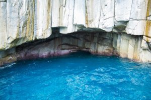
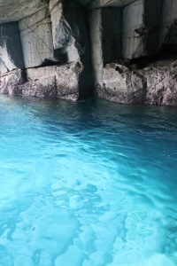
Further along your journey, you’ll come across a sizable opening in the rocky terrain that resembles the mouth of a frog.
The locals refer to it as Gama no kuchi (toad’s mouth), which is Kumano’s rendition of the “Blue Grotto.”
The name was inspired by a tourist spot located on the island of Capri in Southern Italy, owing to the glittering blue waters visible under favorable weather conditions.
This enchanting spot is not accessible by road and can only be reached via the sea.
Continuing your journey towards the north, you’ll encounter a breathtaking columnar joint formation called Tategasaki.
These formations are formed by regular fissures that occur in rock bodies as they contract when the magma flowing on the earth’s surface cools and solidifies.
While there is a walking path from the national highway, opting for a sea route will offer you a splendid view of the towering 80-meter cliff, stretching across 550 meters in circumference.
Exploring the back of Tategasaki will lead you to Umikongo, which emits an enigmatic atmosphere.
As you sail closer, gazing up at the towering cliff from its base, the breathtaking sight will leave you speechless.
The passengers’ cheers reverberate through the sheer rock face, adding to the experience.
Immerse yourself in this dynamic seascape, exclusive to Kumano.
Kumano City Tourism Corporation ☎0597-89-2229
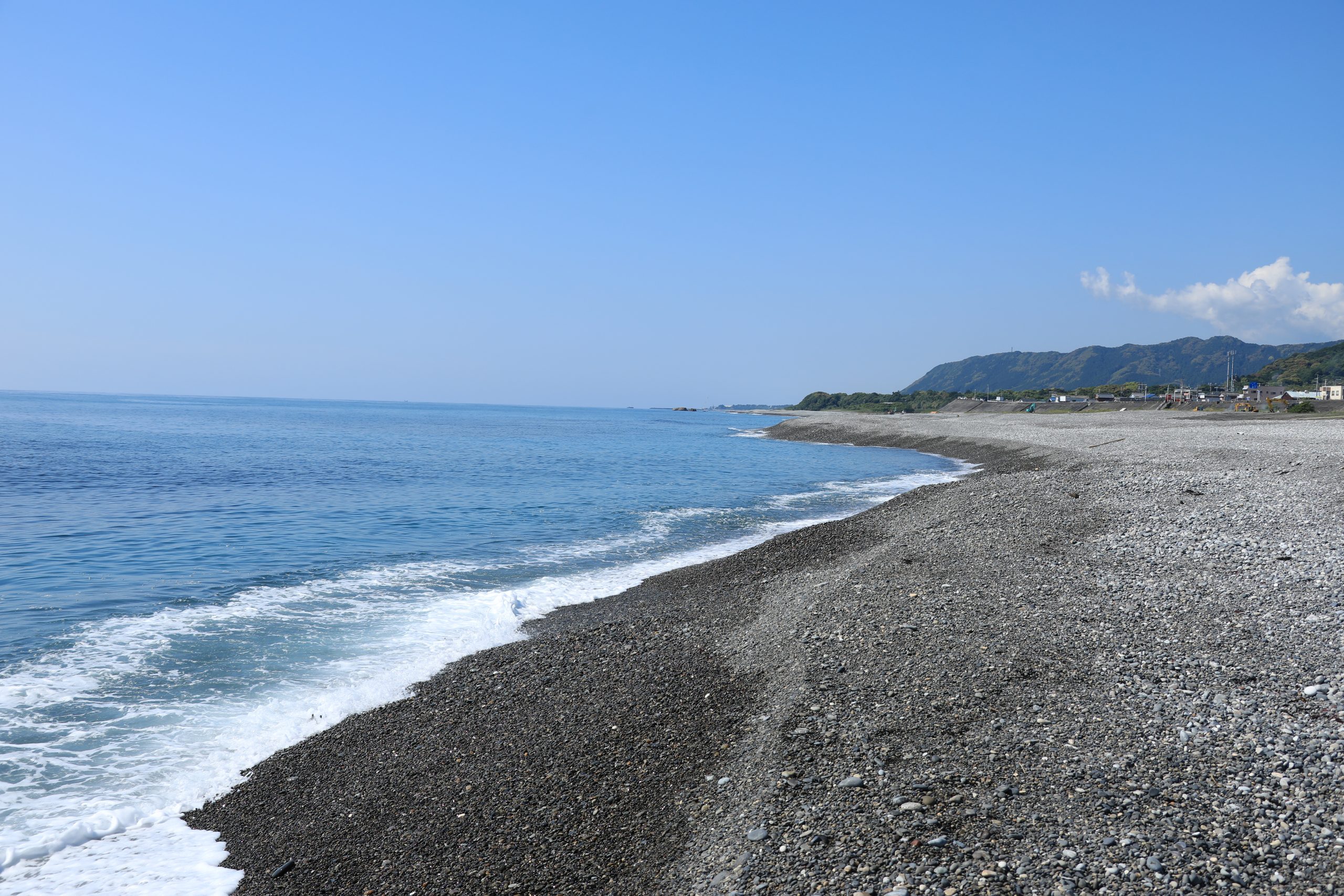
5 Shichirimihama [Kumano City, Mihama-cho, Kiho-cho] World Heritage Site
The 100 Beaches of Japan 100 Natural Wonders of Japan in the 21st Century
 Shichirimihama is the longest gravel coast in Japan, extending approximately 22 km from Kumano City to Kiho-cho.
This stunning beach has been selected as one of “The 100 Beaches of Japan” and holds historical significance as a path of faith called Hamakaido (a designated World Heritage Site) for pilgrims who journeyed to Kumano in ancient times.
Additionally, Shichirimihama is renowned for being a popular nesting ground for loggerhead turtles, which come ashore from spring to summer.

The coast of Shichirimihama is characterized by an abundance of polished gravel, caused by the turbulent waves of Kumano-nada and the rough Kuroshio current (also known as the Black or Japan Current).
These diverse stones are carried downstream from the upriver area of Kumano River and deposited along the shoreline.
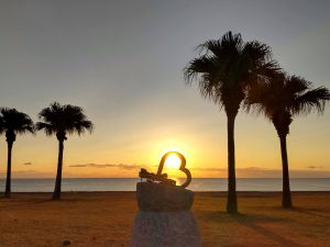
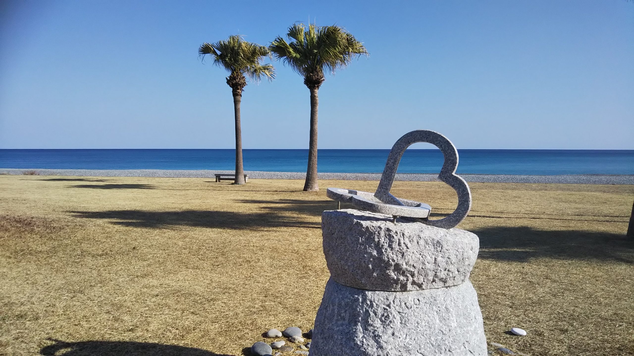
Located overlooking Shichirimihama Beach and Kumano-nada is the Shichirimihama Fureai Beach park.
To find the picturesque spot with a heart-shaped monument, keep an eye out for the coconut trees along the national route.
Immerse yourself in the magnificent sea view before your eyes in this tropical paradise-like setting.